

Where the Tides End – The Troy Federal Lock and Dam
Downstate may have the wider Hudson River and gorgeous scenery, but it's not shabby in the Capital Region. Troy and Waterford are the gateways to the Erie and Champlain Canals! We've got locks!

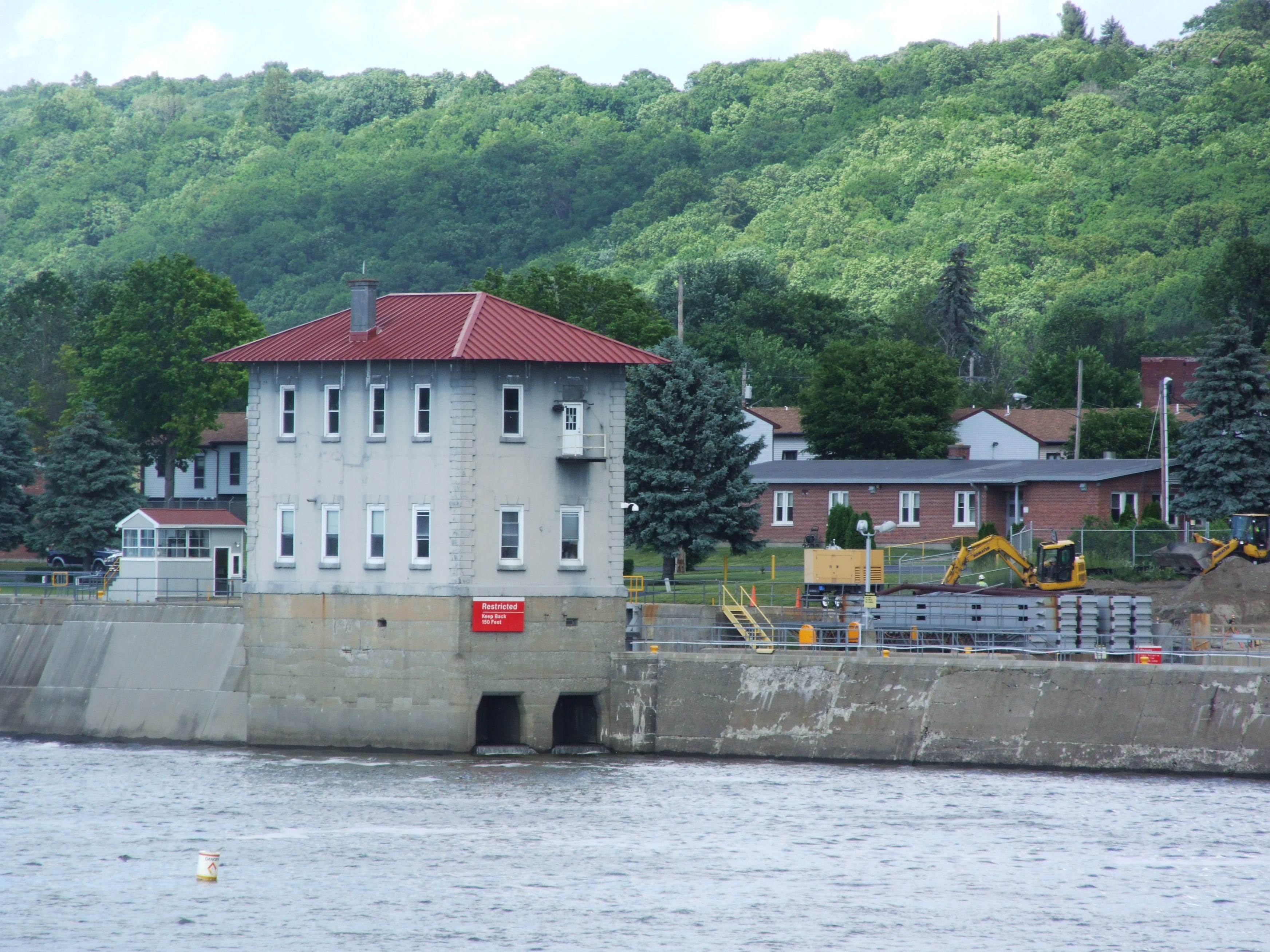
(The Troy Federal Lock. Photo: Suzanne Spellen)
The world is full of majestic rivers, and those of us who live along the Hudson River are blessed with one of the most beautiful of those rivers running past our cities and towns. For thousands of years, the view of the Hudson inspired the Native Americans who first discovered it and used its resources, followed by over 500 years of inspiration and use by Western artists, poets, tourists and river-faring men and women.
We here in the Capital Region may not live along the widest or the most beautiful part of the river, but we have what no one else does – the meeting place of two great rivers; the Hudson and the Mohawk, and the starting locks of both the Erie and Champlain Canals in Waterford. Aside from the technology and beauty of these locations, we are in the midst of the economic engine that made New York the “Empire State.”
If you happen to be in a craft on the Hudson River near Troy, and you come to a waterfall that crosses the river between Troy and Green Island, you have reached the Troy Federal Lock, and it is the first lock on the northwestern route of the Erie Canal that eventually takes you across New York State to Lake Ontario. Technically speaking, it’s also the first lock you come to on the northward journey up the Champlain Canal to Lake Champlain and on to the St. Lawrence Seaway. Pretty important place, I’d say.
The Troy Federal Lock is very different from the other locks in the New York State Canal system. It’s the only one that’s not owned by the State of New York. As the name says, this is a federal lock, owned by the U.S. government and operated by the Army Corp of Engineers. Along with the lock, there is also a federally controlled dam that spans the rest of the river.
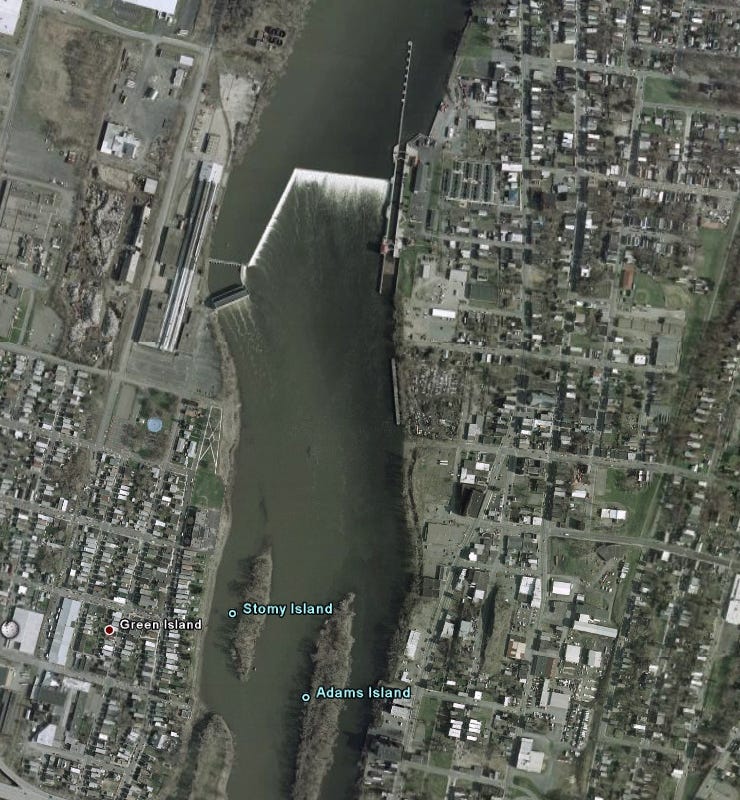
(Photo: Google Earth)
Why the Dam and Lock Were Built
The Troy Federal Lock and Dam were built between 1913 and 1915 and opened in 1916 by the government, as the Hudson River is part of the Federal Navigable Waterway system. The planning for the project began as early as 1903, when blueprints were drawn up. Many of the laborers who built the lock also worked on the Panama Canal.
At the time, the Erie and Champlain Canals were both bustling with barge and other boat traffic, as the waterways were still the cheapest way to move goods from the Great Lakes, New England and Canada, and more convenient than trains. Trucking was not yet a viable or feasible option, and wouldn’t be for another half century.
According to Bill Petronis, Troy Lock & Dam chief with the U.S. Army Corps of Engineers in 2009, “the original plan was to generate hydropower, but the federal government decided not to do that, so Henry Ford built a hydro plant in the early 1920s for his operation across the river from us in Green Island. Our dam is for navigation and to raise the upstream pool elevation so boats can pass thought the lock.” (Times Union, 30 Sept. 2009.)
Building these structures was a massive project, involving dredging the river to allow for heavier boats, and stopping the flow of the Hudson in order to build up the wide L-shaped dam that spans the river, allowing water to drop down an angled 15 foot waterfall. The western side of the dam leads to a spillway and power station, now run by the Green Island Power Authority, while the eastern side of the river; the Troy side, holds the lock.
At the time that it was under construction, State officials were very happy that the lock and dam were federal projects, because that meant the State didn’t have to foot the bill. And then Henry Ford took over building the power plant. But it did cause some confusion in the numbering of the locks.
The State’s Erie Canal lock system begins with Lock E2 in Waterford. There is no Lock E (for Erie) 1. Technically that’s the Troy Lock, aka Lock 1. The Champlain Canal technically starts in Waterford, above the lock, so the Waterford Lock on the Champlain system is called Champlain Lock 1, as it has been since 1817. Okay, now that that is clear…
The Troy Lock is quite long and hugs the eastern side of the river smack in the middle of North Central. It’s a single chamber lock that is 520 feet long, 45 feet wide and 17 feet deep. During its normal operating depths, it lifts boats up or lowers them down 14 feet.
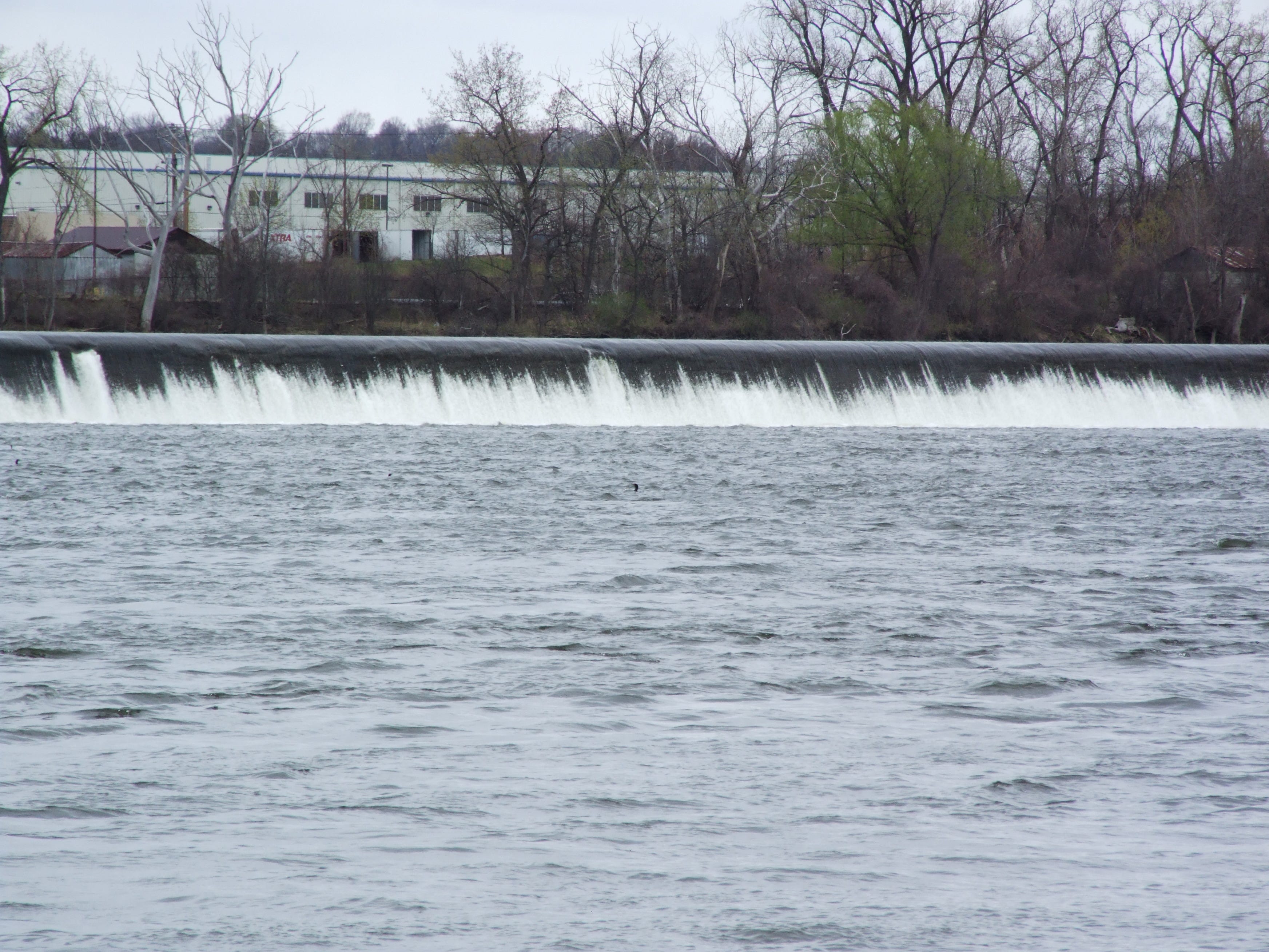
(Waterfall with the powerplant behind it. Photo: Suzanne Spellen)
The Mighty Hudson River
Technically speaking, the Hudson River from New York City up to the Troy Dam is an estuary, which is defined as a tidal inlet; a transitional body of water that joins a fresh water river with the sea. Salt water actually flows in the Hudson up to about the Tappan Zee Bridge, and during drought, the salt line has reached as far north as Poughkeepsie.
The tides run past Albany and past downtown Troy up to the dam. We have two high and two low tides in the river south of the dam. Obviously, the water above the dam is no longer tidal, and does its best to run south to the sea, which is called an ebb flow.
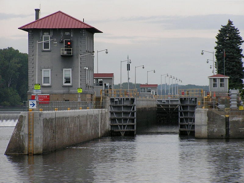
(Troy Federal Lock. Photo: Wikipedia)
The Troy Lock and Dam
The Troy lock is located along the river beginning near Smith Street and continuing up to almost 101st Street. In addition to the lock walls themselves, the installation also has some out buildings at the end of Bond Street and the lock is manned in a control building on the river. Most of the upper part of the lock is behind the Troy Housing Authority’s Fallon Houses.
If you’ve ever seen the locks in Waterford, or in other towns along the canal systems, you’d know that all of this is complex and impressive. It’s fascinating to watch a boat go into the lock, see them close the massive gates, and stand on the bridge over Lock 2 and watch the lock fill up and then release the boat at a higher level to continue along its way.
It really gives one a great sense of appreciation of the engineering skills our forefathers had. Skills and principles that have not changed but have just been upgraded with modern materials and electricity.
The Waterford and other canal locks are great attractions for that reason. But Troy Lock is not. Most people don’t even know where it is. That’s because the entire site is fenced away and blocked from view. There aren’t even any signs. Perhaps for national security, perhaps because it never entered their minds that people would love to watch boats pass through, or perhaps because it is not in an upscale part of Troy. I don’t know.
One has to cross the bridge to Green Island in order to see anything of the lock and dam. You can see it all in its majesty as you cross the Green Island Bridge, and then if you make a right on Cannon Street in Green Island and drive down to the park that is across from the lock. It’s a really lovely park with a fantastic view of the Hudson. Why don’t we have that? It’s the TROY Lock and Dam!
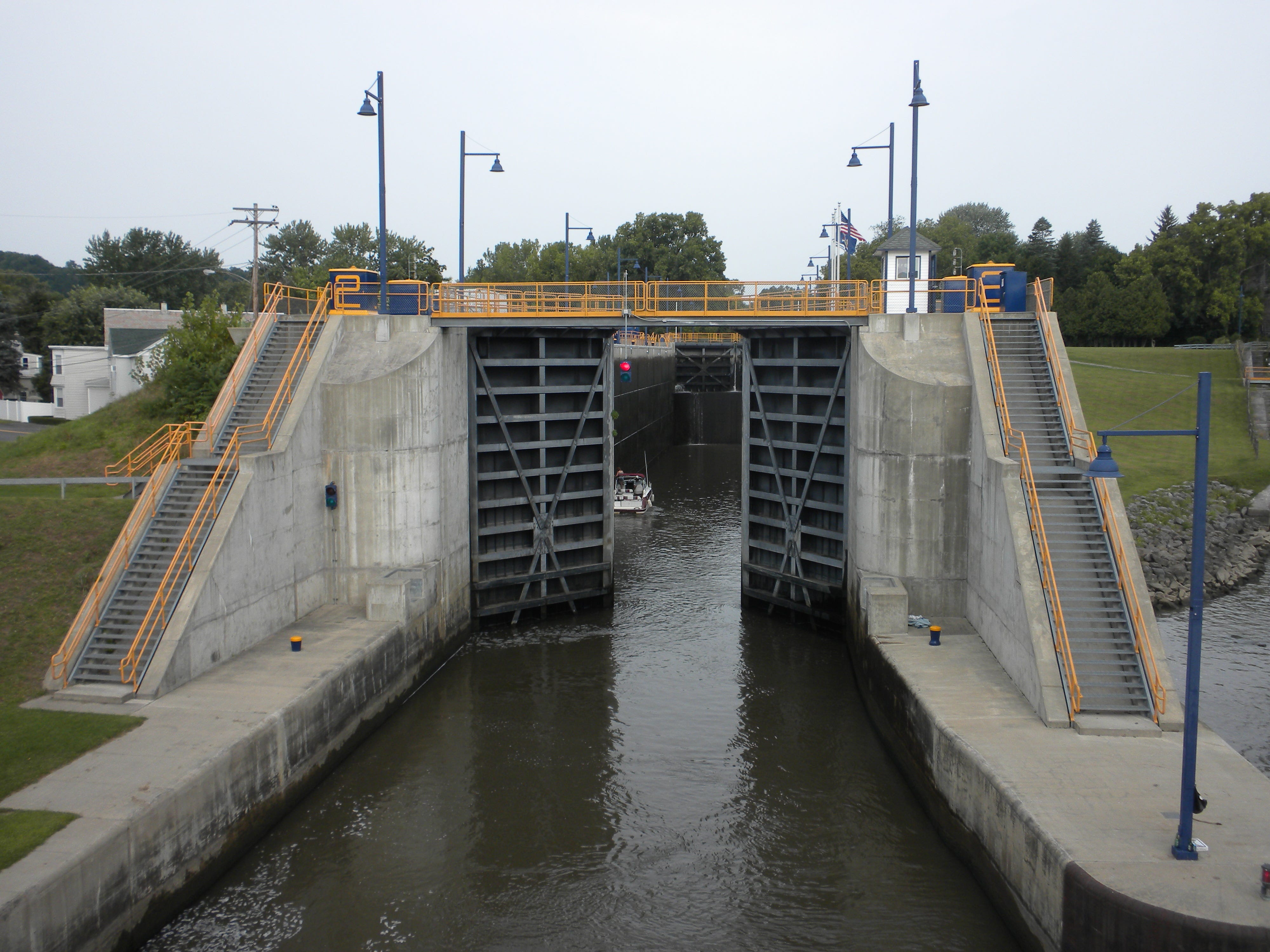
(Lock 2 in nearby Waterford. (Erie Canal) Photo: Suzanne Spellen)
This is one of Troy’s most important civil engineering projects. We should be able to view it from our own city. As Troy continues to change for the better, I hope there are plans to ask the Army Corp of Engineers to somehow make it possible to add the lock to our city’s tourist destinations, while becoming a vital part of North Central’s own renaissance.
If you’d like to see how awesome the lock is, please view the following YouTube video:
My uncle, James Donahue was an assistant and later head lock master at the Troy locks in the 50’s and 60’s. We used to come to visit in the summers, up from Queens. We stayed at their private government provided home on the grounds. It was so great coming up from the city, and that little oasis in Troy was really beautiful. We would watch as pleasure cruisers would come through and talk to the people as their boat slowly rose up. I know the compound looks a little foreboding now and Bond St has seen better days. I drive through the area recently with my 15 year old daughter to give her a little history. I imagine having a “visitors center” on the grounds is too much to ask Army Corps of Engineers these days and you’ll just have to watch from across the river
Looks tranquil. How's the fishing?